


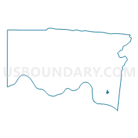
Voting District ANDERSON CC, Hamilton County, Ohio
About
Outline

Summary
| Unique Area Identifier | 647298 |
| Name | Voting District ANDERSON CC |
| County | Hamilton County |
| State | Ohio |
| Area (square miles) | 0.21 |
| Land Area (square miles) | 0.21 |
| Water Area (square miles) | 0.00 |
| % of Land Area | 100.00 |
| % of Water Area | 0.00 |
| Latitude of the Internal Point | 39.08690700 |
| Longtitude of the Internal Point | -84.36563440 |
Maps

Graphs
Select a template below for downloading or customizing gragh for Voting District ANDERSON CC, Hamilton County, Ohio


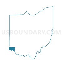
Neighbors
Neighoring Voting District (by Name) Neighboring Voting District on the Map
- Voting District ANDERSON N, Hamilton County, OH
- Voting District ANDERSON NN, Hamilton County, OH
- Voting District ANDERSON P, Hamilton County, OH
- Voting District ANDERSON SS, Hamilton County, OH
- Voting District ANDERSON V, Hamilton County, OH
- Voting District CINCINNATI 1-Q, Hamilton County, OH
Top 10 Neighboring County Subdivision (by Population) Neighboring County Subdivision on the Map
Top 10 Neighboring Place (by Population) Neighboring Place on the Map
- Cincinnati city, OH (296,943)
- Turpin Hills CDP, OH (5,099)
- Fruit Hill CDP, OH (3,755)
- Sherwood CDP, OH (3,719)